Hide Map
Show Map

Energy-Water Nexus
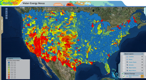 Water and energy are strongly interrelated and the links between the two systems are expected to
intensify further in the future. The energy sector withdraws more water than any other sector in
the United States, mainly for power generation. Similarly, the water sector relies heavily on
energy for water supply and water treatment (including desalinization). The interdependency
between energy and water is referred to as Energy-Water (EW) Nexus. The intent of this module
is to introduce students to Energy-Water Nexus and analyze stresses on water system under
different scenarios of current and future energy demands, including factors such as fuel type,
cooling technologies, greenhouse regulations, and population growth. The analysis is done at the
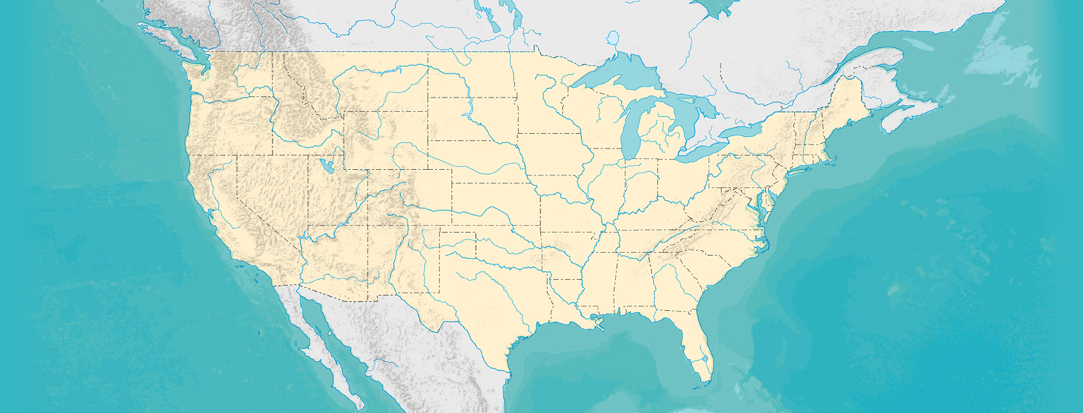
scale of eight-digit watershed hydrologic unit code (HUC8).
Water and energy are strongly interrelated and the links between the two systems are expected to
intensify further in the future. The energy sector withdraws more water than any other sector in
the United States, mainly for power generation. Similarly, the water sector relies heavily on
energy for water supply and water treatment (including desalinization). The interdependency
between energy and water is referred to as Energy-Water (EW) Nexus. The intent of this module
is to introduce students to Energy-Water Nexus and analyze stresses on water system under
different scenarios of current and future energy demands, including factors such as fuel type,
cooling technologies, greenhouse regulations, and population growth. The analysis is done at the
scale of eight-digit watershed hydrologic unit code (HUC8).
Extended Summary Go-to Module
Logan Dry Canyon Flash Flood Protection

Logan Dry Canyon Flash Flood Protection, Rocky Mountains, Utah
 Flash flooding is a hazard in many parts of the world. In the Rocky Mountains,
flash flooding is common in mountain canyons, desert washes, and other such topographic areas featuring mountainous terrain where runoff from rainfall quickly accumulates in
gullies or ravines. With a growing population, developing neighborhoods in terrains susceptible to flash floods have become more common and have therefore increased the potential
for damage to private property and public infrastructure. In this module, you will learn about the topics in hydrology needed to design a detention basin to protect an area of
urban development from flooding.
Flash flooding is a hazard in many parts of the world. In the Rocky Mountains,
flash flooding is common in mountain canyons, desert washes, and other such topographic areas featuring mountainous terrain where runoff from rainfall quickly accumulates in
gullies or ravines. With a growing population, developing neighborhoods in terrains susceptible to flash floods have become more common and have therefore increased the potential
for damage to private property and public infrastructure. In this module, you will learn about the topics in hydrology needed to design a detention basin to protect an area of
urban development from flooding.
Extended Summary Go-to Module
Climate Teleconnections
Climate Teleconnections, with an application in the Everglades
 Climate variability and the influence of remote oceanic and atmospheric conditions on regional precipitation and temperature are important concepts for
understanding how local water balance evolves over long periods of time, and also how extreme hydrologic events may result from climate patterns that
are organized at global scales. Through this module, students investigate relationship between climate indices and regional hydrological conditions,
with an application in south Florida, and consider how climate teleconnections can be leveraged in improving seasonal and decadal water management
in these locations.
Climate variability and the influence of remote oceanic and atmospheric conditions on regional precipitation and temperature are important concepts for
understanding how local water balance evolves over long periods of time, and also how extreme hydrologic events may result from climate patterns that
are organized at global scales. Through this module, students investigate relationship between climate indices and regional hydrological conditions,
with an application in south Florida, and consider how climate teleconnections can be leveraged in improving seasonal and decadal water management
in these locations.
Extended Summary Go-to Module
Water Budget Analysis for Chenier Plain
Water Budget Analysis for Chenier Plain, Coastal Louisiana
 Water budget analysis of large coastal basins provide a basis for understanding the hydrologic and ecologic processes of the ecosystem, its ecological
functions and services, and predicting effects of natural and human hydrologic alterations. In this module, you will use the output of a spatially-distributed
mass-balance model to perform a water budget analysis for the Louisiana Chenier Plain ecosystem. In this analysis, you will examine budget variability at inter-
and intra-annual scales.
Water budget analysis of large coastal basins provide a basis for understanding the hydrologic and ecologic processes of the ecosystem, its ecological
functions and services, and predicting effects of natural and human hydrologic alterations. In this module, you will use the output of a spatially-distributed
mass-balance model to perform a water budget analysis for the Louisiana Chenier Plain ecosystem. In this analysis, you will examine budget variability at inter-
and intra-annual scales.
Extended Summary Go-to Module
Vermilion Bay Oyster Reef Restoration Project

Vermilion Bay Oyster Reef Restoration Project, Coastal Louisiana
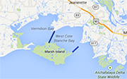 Bioengineered oyster barrier reefs are used as a viable restoration technique that can improve oyster propagation and serve as breakwaters to attenuate wave
energies. The 2012 Louisiana Coastal Master Plan list of proposed projects includes one such reef located between West and East Cote Blanche Bays, to the
east of Vermilion Bay. This analysis will determine the hydrologic impact of the proposed oyster reef project on the region and if the addition of an oyster
reef will be to the benefit or detriment of one of the many commercially valuable aquatic species found in the bays under analysis.
Bioengineered oyster barrier reefs are used as a viable restoration technique that can improve oyster propagation and serve as breakwaters to attenuate wave
energies. The 2012 Louisiana Coastal Master Plan list of proposed projects includes one such reef located between West and East Cote Blanche Bays, to the
east of Vermilion Bay. This analysis will determine the hydrologic impact of the proposed oyster reef project on the region and if the addition of an oyster
reef will be to the benefit or detriment of one of the many commercially valuable aquatic species found in the bays under analysis.
Extended Summary Go-to Module
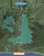
Pecan Island Freshwater Introduction Project: Feasibility Analysis

Pecan Island Freshwater Introduction Project: Feasibility Analysis, Coastal Louisiana
 Wetlands in Louisiana’s Chenier Plain are undergoing persistent deterioration that will become increasingly problematic if not adequately addressed. While
the cause of the problem is sometimes apparent the solution is not always as straightforward. Many restoration plans are proposed and their acceptance depends
on many factors the first and foremost of which is the feasibility of the proposed project. This module examines a proposed restoration project aimed at reducing
salinity levels in a coastal marsh area by increasing the introduction of freshwater to the area. To assess the feasibility of the project a lumped box model is
constructed in which meteorological fluxes and flow exchanges through local control are considered and quantified.
Wetlands in Louisiana’s Chenier Plain are undergoing persistent deterioration that will become increasingly problematic if not adequately addressed. While
the cause of the problem is sometimes apparent the solution is not always as straightforward. Many restoration plans are proposed and their acceptance depends
on many factors the first and foremost of which is the feasibility of the proposed project. This module examines a proposed restoration project aimed at reducing
salinity levels in a coastal marsh area by increasing the introduction of freshwater to the area. To assess the feasibility of the project a lumped box model is
constructed in which meteorological fluxes and flow exchanges through local control are considered and quantified.
Extended Summary Go-to Module
Pecan Island Freshwater Introduction Project: Hydraulic Modeling and Design

Pecan Island Freshwater Introduction Project: Hydraulic Modeling and Design, Coastal Louisiana
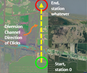 Sustained saltwater intrusion is one of the leading causes of marsh fragility and land loss in coastal Louisiana. A solution to mitigate salt water
intrusion is freshwater introduction projects. The application of this type of restoration project usually involves the dredging or excavation of a new
or existing channel to accommodate the additional freshwater flow. This module concentrates on constructing and utilizing a one-dimensional unsteady flow
model to assist in the hydraulic design of a proposed conveyance channel. This module is based on an actual restoration project that was proposed is South
Pecan Island located in Coastal Louisiana.
Sustained saltwater intrusion is one of the leading causes of marsh fragility and land loss in coastal Louisiana. A solution to mitigate salt water
intrusion is freshwater introduction projects. The application of this type of restoration project usually involves the dredging or excavation of a new
or existing channel to accommodate the additional freshwater flow. This module concentrates on constructing and utilizing a one-dimensional unsteady flow
model to assist in the hydraulic design of a proposed conveyance channel. This module is based on an actual restoration project that was proposed is South
Pecan Island located in Coastal Louisiana.
Extended Summary Go-to Module
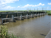
Calcasieu Ship Channel Salinity Control Project

Calcasieu Ship Channel Salinity Control Project, Coastal Louisiana
 The excavation of major navigation channels has led to a steady increase in saltwater intrusion and thus a steady decease in vegetation growth in the fresh and brackish
marshes of coastal Louisiana. To minimize the effects of saltwater intrusion local engineers have developed a series of control structures such as locks and gates. In
this module, students examine the existing hydrologic conditions of the Calcasieu Ship Channel (CSC) region and investigate four alternative proposed control structure
mechanisms for the prevention of saltwater intrusion.
The excavation of major navigation channels has led to a steady increase in saltwater intrusion and thus a steady decease in vegetation growth in the fresh and brackish
marshes of coastal Louisiana. To minimize the effects of saltwater intrusion local engineers have developed a series of control structures such as locks and gates. In
this module, students examine the existing hydrologic conditions of the Calcasieu Ship Channel (CSC) region and investigate four alternative proposed control structure
mechanisms for the prevention of saltwater intrusion.
Extended Summary Go-to Module
Vegetation Analysis in Chenier Plain

Vegetation Analysis in Chenier Plain, Coastal Louisiana
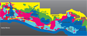 A large portion of the hydrologic studies conducted in coastal Louisiana focus on the protection and restoration of the numerous habitats which reside in it. These
habitats are highly dependent on both the water and salinity level of the marsh type ecosystem in which they reside. In this module, you will build a basic understanding
of the relationship between hydrologic regime and vegetation type in a coastal wetland area by interpreting hydro-ecological field observations and analyse hydrologic indices
to assess marsh health and productivity.
A large portion of the hydrologic studies conducted in coastal Louisiana focus on the protection and restoration of the numerous habitats which reside in it. These
habitats are highly dependent on both the water and salinity level of the marsh type ecosystem in which they reside. In this module, you will build a basic understanding
of the relationship between hydrologic regime and vegetation type in a coastal wetland area by interpreting hydro-ecological field observations and analyse hydrologic indices
to assess marsh health and productivity.
Extended Summary Go-to Module